


Ware Mechanical forecast: Just over quarter inch of rain in last 24 hours, more on the way today.
Situation: Just over a quarter of a inch of rain (..29) was reported at the Rome Airport on Tuesday. There is slight chance of thunderstorms this afternoon. Rainfall totals of up to three inches still possible through Saturday. Hydrologic Outlook is in effect
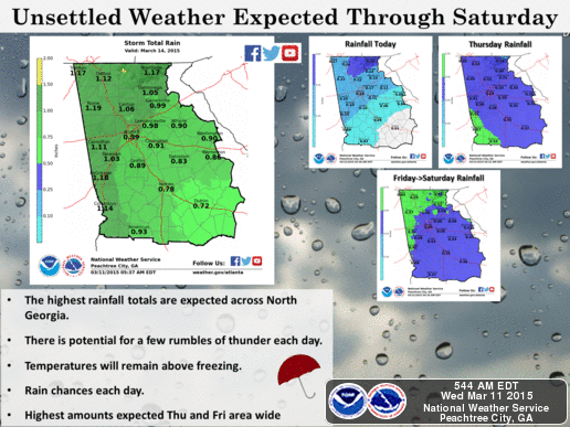
THERE IS A CHANCE OF THUNDERSTORMS ACROSS MAINLY CENTRAL GEORGIA
WEDNESDAY THROUGH FRIDAY. IN ADDITION...WITH RAIN EXPECTED ACROSS
NORTH AND CENTRAL GEORGIA MUCH OF THE WEEK...TOTAL RAINFALL
AMOUNTS OF TWO TO THREE INCHES ARE POSSIBLE THROUGH SATURDAY
ACROSS NORTH GEORGIA. WITH MODELS INDICATING SOME HIGHER AMOUNTS
NEAR FOUR INCHES POSSIBLE MAINLY NORTHWEST...THIS WILL NEED TO BE
WATCHED CLOSELY FOR ANY FLOODING POTENTIAL.
The forecast:
Today: Showers, with thunderstorms also possible after noon. Patchy fog before 10am. High near 67. Calm wind becoming northwest around 5 mph. Chance of precipitation is 80%. New rainfall amounts between a tenth and quarter of an inch, except higher amounts possible in thunderstorms.
Tonight: Showers likely, mainly before midnight. Patchy fog after 4am. Otherwise, mostly cloudy, with a low around 54. Calm wind. Chance of precipitation is 60%.
Thursday: A 50 percent chance of showers, mainly after 7am. Patchy fog before 10am. Otherwise, cloudy, with a high near 66. Light northeast wind becoming east 5 to 10 mph in the morning.
Thursday Night: Showers likely. Cloudy, with a low around 51. East wind 10 to 15 mph. Chance of precipitation is 70%.
Friday: Showers. High near 58. Southeast wind around 10 mph. Chance of precipitation is 80%.
Friday Night: Showers. Low around 52. Chance of precipitation is 80%.
Saturday: Showers likely. Cloudy, with a high near 67. Chance of precipitation is 60%.
Saturday Night: A 20 percent chance of showers. Mostly cloudy, with a low around 49.
Latest local radar / NOAA weather radio
Latest traffic. Click Google Maps or Waze

Editor's picks
- Casino En Ligne Retrait Immédiat
- Meilleur Casino En Ligne
- Siti Di Scommesse
- Uk Sports Betting Sites Not On Gamstop
- Online Casino Sites UK
- Online Betting Sites Not On Gamstop
- Migliori Casino Non Aams
- Casino Online Migliori
- Gambling Sites Not On Gamstop
- Non Gamstop Casino Sites UK
- Meilleur Casino En Ligne Français
- Casino En Ligne Bonus Sans Dépôt
- Meilleur Casino En Ligne Français
- Tous Les Sites De Paris Sportifs Belgique
- Meilleur Casino En Ligne Belgique
- Siti Scommesse Non Aams Sicuri
- App Scommesse Sportive
- Meilleur Site Pour Jouer Au Poker
- Tennis Paris Sportif
- Meilleur Site De Paris Sportif International
- Sweet Bonanza Fruits Avis
- Paris Sportif Ufc
- ライブカジノ
- 銀行出金が早いオンカジ
- ライブカジノ
- 암호화폐 베팅사이트
- лучшие казино Украины
- Paris Sportif Crypto
- Casino En Ligne 2026
- Nouveau Site De Casino En Ligne
- Migliori App Casino Online
- I Migliori Casino Non Aams
- 스포츠토토
- Trang Cá độ Bóng đá
- Casino En Ligne Argent Réel France
- Nouveau Casino En Ligne 2026
- Meilleurs Casino En Ligne
- Siti Casino Non Aams
- Casino Aams Nuovi